
Blog Elements
You can display blog posts in various ways with the “Blog Post” element/shortcode. You can see one example here and even more at the blog main menu item of this demo.
 https://contentthatmoves.com/wp-content/uploads/2021/11/ctmlogo-centered-3.png
0
0
stevebutton
https://contentthatmoves.com/wp-content/uploads/2021/11/ctmlogo-centered-3.png
stevebutton2020-04-09 08:06:482020-04-09 08:06:48Open Mapping the Global Goals at the World Data Forum
https://contentthatmoves.com/wp-content/uploads/2021/11/ctmlogo-centered-3.png
0
0
stevebutton
https://contentthatmoves.com/wp-content/uploads/2021/11/ctmlogo-centered-3.png
stevebutton2020-04-09 08:06:482020-04-09 08:06:48Open Mapping the Global Goals at the World Data Forum https://contentthatmoves.com/wp-content/uploads/2020/04/90a1ebe6-5a70-4421-b031-f42ea70838d7.jpg
435
435
stevebutton
https://contentthatmoves.com/wp-content/uploads/2021/11/ctmlogo-centered-3.png
stevebutton2020-04-09 08:05:422020-04-09 08:05:42Hurricane Matthew: Who’s at Risk?
https://contentthatmoves.com/wp-content/uploads/2020/04/90a1ebe6-5a70-4421-b031-f42ea70838d7.jpg
435
435
stevebutton
https://contentthatmoves.com/wp-content/uploads/2021/11/ctmlogo-centered-3.png
stevebutton2020-04-09 08:05:422020-04-09 08:05:42Hurricane Matthew: Who’s at Risk? https://contentthatmoves.com/wp-content/uploads/2020/04/e723b12a-c551-4db4-908e-982cd3b3fd38.jpg
287
510
stevebutton
https://contentthatmoves.com/wp-content/uploads/2021/11/ctmlogo-centered-3.png
stevebutton2020-04-09 08:01:102020-04-09 08:01:10How We Identified Burned Villages in the Democratic Republic of Congo – The New York Times
https://contentthatmoves.com/wp-content/uploads/2020/04/e723b12a-c551-4db4-908e-982cd3b3fd38.jpg
287
510
stevebutton
https://contentthatmoves.com/wp-content/uploads/2021/11/ctmlogo-centered-3.png
stevebutton2020-04-09 08:01:102020-04-09 08:01:10How We Identified Burned Villages in the Democratic Republic of Congo – The New York Times https://contentthatmoves.com/wp-content/uploads/2020/04/d1e9ba95-e5af-4446-8843-d2c0f62599cc.jpg
629
799
stevebutton
https://contentthatmoves.com/wp-content/uploads/2021/11/ctmlogo-centered-3.png
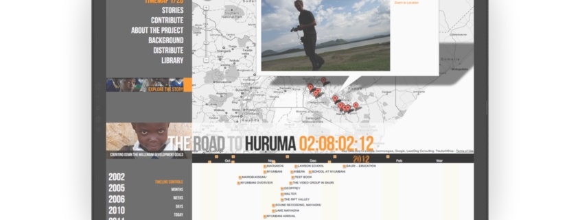
stevebutton2020-04-09 07:58:052020-04-09 07:58:05· Create interactive maps
https://contentthatmoves.com/wp-content/uploads/2018/04/mockup-6.jpg
1418
1500
stevebutton
https://contentthatmoves.com/wp-content/uploads/2021/11/ctmlogo-centered-3.png
stevebutton2018-04-17 22:21:532020-04-10 12:31:28Invitation!
https://contentthatmoves.com/wp-content/uploads/2021/11/ctmlogo-centered-3.png
0
0
stevebutton
https://contentthatmoves.com/wp-content/uploads/2021/11/ctmlogo-centered-3.png
stevebutton2017-07-28 02:27:462017-07-28 02:27:46Hello world!
https://contentthatmoves.com/wp-content/uploads/2020/04/d1e9ba95-e5af-4446-8843-d2c0f62599cc.jpg
629
799
stevebutton
https://contentthatmoves.com/wp-content/uploads/2021/11/ctmlogo-centered-3.png
stevebutton2020-04-09 07:58:052020-04-09 07:58:05· Create interactive maps
https://contentthatmoves.com/wp-content/uploads/2018/04/mockup-6.jpg
1418
1500
stevebutton
https://contentthatmoves.com/wp-content/uploads/2021/11/ctmlogo-centered-3.png
stevebutton2018-04-17 22:21:532020-04-10 12:31:28Invitation!
https://contentthatmoves.com/wp-content/uploads/2021/11/ctmlogo-centered-3.png
0
0
stevebutton
https://contentthatmoves.com/wp-content/uploads/2021/11/ctmlogo-centered-3.png
stevebutton2017-07-28 02:27:462017-07-28 02:27:46Hello world! We support our work through toolbox – a series of digital “magazines” that provide relevant, shareable content that guides and re-inforces our work.